List of Contents
Key points
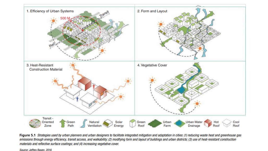
- Urban waste heat and GHG emissions from infrastructure – including buildings, transportation, and industry – can be reduced through improvements in the efficiency of urban systems.
- Modifying the form and layout of buildings and urban districts can provide cooling and ventilation that reduces energy use and allow citizens to cope with higher temperatures and more intense runoff.
- Selecting low heat capacity construction materials and reflective coatings can improve building performance by managing heat exchange at the surface.
- Increasing the vegetative cover in a city can simultaneously lower outdoor temperatures, building cooling demand, runoff, and pollution, while sequestering carbon.
Discover ARC3.3
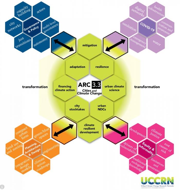
UCCRN edu is proud of its active participation in the development and dissemination of innovative content for ARC3.3, a publication by Cambridge University Press. Discover the new ARC3.3 release!
Urban planning and urban design have a critical role to play in the global response to climate change. Actions that simultaneously reduce greenhouse GHG emissions and build resilience to climate risks should be prioritized at all urban scales – metropolitan region, city, district/neighborhood, block, and building. This needs to be done in ways that are responsiveto and appropriate for local conditions.
Urban planning definition
A field of practice that helps city leaders to transform a sustainable development vision into reality using space as a key resource for development and engaging a wide variety of stakeholders in the process. It generally takes place at the scale of the city or metropolitan region whose overall spatial pattern it sets. Good urban planning formulates medium- and long-term objectives that reconcile a collective vision with the rational organization of the
resources needed to achieve it. It makes the most of municipal budgets by informing infrastructure and services investments and balancing demands for growth with the need to protect the environment. And it ideally distributes economic development within a given urban area to reach wider social objectives (UN-Habitat 2013).
Urban design definition
Urban design involves the arrangement and design of buildings, public spaces, transport systems, services, and amenities; it is the process of giving form, shape, and character to groups of buildings, to whole neighborhoods, and to a city, a framework that orders the elements into a network of streets, squares, and blocks. Urban design blends architecture, landscape architecture and city planning together to make urban areas functional and attractive and is about making connections between people and places, movement and urban form, nature and the built fabric. Urban design also draws together the many strands of place-making, environmental stewardship, social equity, and economic viability into the creation of places with distinct beauty and identity, it draws together to create a vision for an urban area and then deploys the resources and skills needed to bring the vision to life (urbandesign.org).

Urban Form and Function
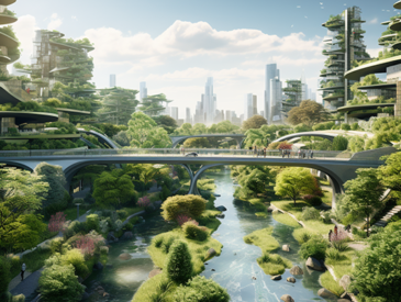
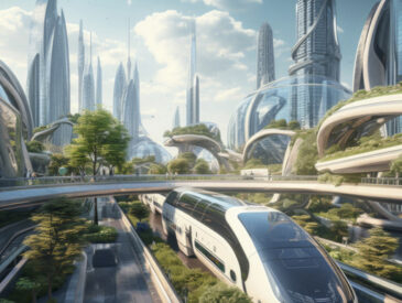
Forward-thinking cities are beginning to exploit the positive potential of built and natural systems – including green infrastructure, urban ventilation, and solar orientation – to “futureproof” the built environment in response to changing conditions. These passive urban design strategies “lock in” long-term resilience and sustainability, protecting the city from future decisions that could undermine its adaptability. They also remove the risk of relying on bolted-on, applied technologies that may require expensive maintenance or become obsolete in a short time. These form-based, contextually specific urban planning and urban design strategies are the ultimate guarantors of successful life cycle costs, payback, and liveability. Integrated mitigation and adaptation in cities can assume many forms across spatial scales, urban systems, and physical networks; a wide range of strategies adopted in service of urban sustainability already advances this objective. Enhanced urban transit, for example, has the effect of reducing both carbon emissions from single-occupant vehicle use and waste heat emissions that contribute to the urban heat island effect. Investments in pedestrian and cycling corridors, particularly when integrated with parks and other green spaces in cities, can reduce carbon emissions, enhance carbon sequestration, and, perhaps most effectively, cool cities through evapotranspiration and shading.
The physical character of cities can be described by three aspects of form: land cover, urban materials, and morphology. On the other hand, the flow of materials through a city describes its metabolism, the character of which is regulated by its functions:
- Surface cover (Form): the replacement of natural land covers by impermeable materials limits the infiltration of precipitation into the substrate, increases runoff, and decreases evapotranspiration.
- Construction materials and surface coating (Form): common urban materials such as concrete have high conductivity and heat capacity values that can store heat efficiently. Also, many urban materials are dark colored and reflect poorly.
- Morphology (Form): the configuration and orientation of the built environment, from regional settlement patterns to buildings, create a corrugated surface that slows and redirects near-surface airflow and traps radiation.
- Urban activities (Function): cities concentrate material, water, and energy use that must be acquired from a much larger area. Some is used to build the city (changing its form), but most is employed to sustain its economy and society. Once used, the wastes and emissions are deposited into the wider environment, degrading soil, water, and air quality, and increasing heat through the exacerbated greenhouse effect.
Urban climate zones
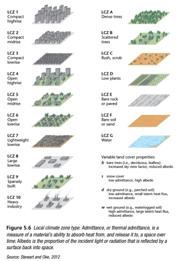
The changes that accompany urbanization have profound impacts on the local environment and are clearly seen in aspects of climate and hydrology (Hough, 1989) (see Chapter 2 Urban Climate Science). The magnitude of these urban effects depends on both the form and functions of individual cities. However, cities are highly heterogeneous landscapes, and impacts vary across the urbanized area as well. Detailed mapping of urban layout, including aspects of form (e.g., impervious land cover) and of function (e.g., commercial land use), provides a basis for examining climate at a local scale. For example, Stewart and Oke (2012) have developed a simple scheme that classifies urban neighborhoods mainly by form into local climate zones (LCZ) (see Figure 5.6). Each LCZ is characterized by typical building heights, street widths, vegetative cover, and paved area. Not surprisingly, the most intense local climate impacts are found where building density is greatest, streets are narrowest, and there is little vegetation (e.g., compact high-rises or dense slums). In many of these areas, the population is highly vulnerable due to poverty or age (see Chapter 6, Equity and Environmental Justice). Cities comprise many LCZ types that occupy varying proportions of the urbanized landscape.
Planning and urban design standards
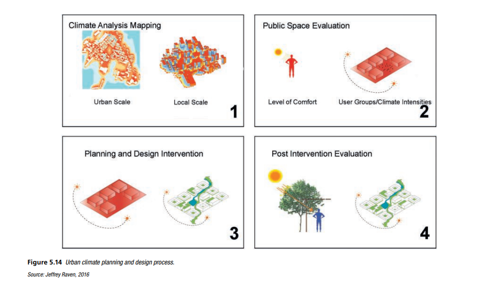
A planning and design approach to urban climate intervention should follow a four-phase approach: climate analysis mapping, public space evaluation, planning and design intervention, and post-intervention evaluation (see Figure 5.14).
Climate Analysis and Mapping
Considering climate in urban planning and urban design, the first step is to understand large-scale climatic conditions and individual inner-city local climates, including their reciprocal interactions (see Figure 5.14). Considerations include:
• Regional occurrence and frequency of air masses exchange (ventilation) and their frequencies;
• Seasonal occurrence of the thermal and air quality effects of urban climate (stress areas, insolation rates, shading conditions);
• Regional presentation and evaluation of the impact area and stress areas;
• Energy optimization of location based on urban climate analysis with regard to areas with heat load, cooler air areas, and building density.
Climate analyses and maps provide a critical first step in identifying urban zones subject to the greatest impacts associated with rising temperatures, increasing precipitation, and extreme weather events (see Figure 5.14).
Evaluation of Public Space
Urban climate is an essential part of urban planning evaluation. Urban climate maps are increasingly used in the planning process for urban development as well as for open space design. The public should be involved at all stages through the use of interactive geographical information systems and/or surveys that help citizens foresee potential land-use changes (see Figure 5.14). This is enabled by climatic evaluation through spatial and temporal quantitative descriptions and specifications. At the regional level, areas worth protecting by virtue of their climatic functions, e.g., areas of heat load, fresh air supply, and ventilation pathways are identified as key targets for planning measures.
Planning and Design Interventions
The task of planning and designing interventions relevant to urban climatology is to improve thermal conditions and air quality:
• Reduction of UHIs (heat islands being an indication of thermal comfort/discomfort) through open space planning.
• Optimization of urban ventilation via air exchange and wind corridors.
• Prevention of stagnating air in stationary temperature inversion conditions by eliminating barriers to air exchange.
• Maintenance and promotion of fresh air or cool air generation areas to further air exchange and improve air quality.
Regional specifications may include sustaining cool air or fresh air generation areas (slopes) or ventilation lanes and taking into consideration building orientation, building height, and density of development. Such specifications may be implemented according to building codes in urban land-use planning.
Post-Intervention Evaluation
Field measurement studies should be conducted to assess the microclimatic performance of the urban design and planning intervention. Infrared thermal imaging and/or population surveys can be undertaken to assess temperature variations compared to conditions prior to intervention. Climate-resilient strategies can have the effect of moderate temperatures with associated benefits to public health and energy savings.
References
Coordinating Lead Author
Jeffrey Raven (New York)
Lead Authors
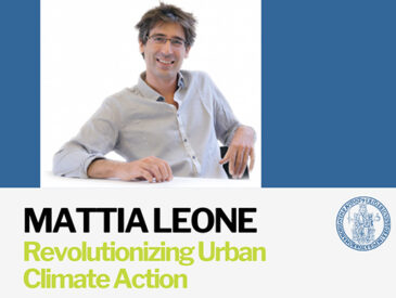
Brian Stone (Atlanta), Gerald Mills (Dublin), Joel Towers (New York), Lutz Katzschner (Kassel), Mattia Federico Leone (Naples), Pascaline Gaborit (Brussels), Matei Georgescu (Tempe), Maryam Hariri (New York).
Contributing Authors
James Lee (Shanghai/Boston), Jeffrey LeJava (White Plains), Ayyoob Sharifi (Tsukuba/Paveh), Cristina Visconti (Naples), Andrew Rudd (Nairobi/New York).
Urban planning definition
- Mentens, J., Raes, D., and Hemy, M. (2006). Green roofs as a tool for solving the rainwater runoff problem in the urbanized 21st century? Landscape and Urban Planning 77, 217–226
- Ong, B. L. (2003). Green plot ratio: An ecological measure for architecture and urban planning. Landscape and Urban Planning 63(4), 197–211.
- UN-Habitat. (2013). Urban Planning for City Leaders. UN-Habitat.
Urban design definition
- Australian Sustainable Built Environment Council (ASBEC). (2013). What is urban design? Accessed April 11, 2014: http://www.urbandesign.org.au/whatis/index.aspx
- BMT WBM Pty Ltd. (2009). Evaluating options for water sensitive urban design: A national guide. Joint Steering Committee for Water Sensitive Cities (JSCWSC), Australia
- Brophy, V., O’Dowd, C., Bannon, R., Goulding, J., and Lewis, J. O. (2000). Sustainable urban design. Energy Research Group, University College Dublin
Urban form and function
- Miller, N., Cavens, D., Condon, P., Kellett, N., and Carbonell, A. (2008). Policy, urban form and tools for measuring and managing greenhouse gas emissions: The North American problem. Climate change and urban design: The third annual congress of the Council for European Urbanism, Oslo.
- Mills, G. (2005). Urban form, function and climate. Dept. of Geography, University of California, Davis. Accessed August 30, 2014;
- Stone, B., Hess, J., and Frumkin, H. (2010). Urban form and extreme heat events: Are sprawling cities more vulnerable to climate change? Environmental Health Perspectives 118, 1425–1428.
Urban climate zones
- McGranahan, G., et al. (2007). The rising tide: Assessing the risks of climate change and human settlements in low elevation coastal zones. Environment and Urbanisation 19, 17–37.
- Stewart, I. D., and Oke, T. R. (2012). Local climate zones for urban temperature studies. Bulletin of the American Meteorological Society 93(12),1879–1900.
Planning and urban design standards
- American Planning Association (APA). (2015). What is planning?. American Planning Association. Accessed March 20, 2016: https://www.planning.org/aboutplanning/whatisplanning.htm
- Dickie, S., Ions, L., McKay, G., and Shaffer, P. (2010). Planning for SuDS – Making it Happen. Ciria
- Mentens, J., Raes, D., and Hemy, M. (2006). Green roofs as a tool for solving the rainwater runoff problem in the urbanized 21st century? Landscape and Urban Planning 77, 217–226